| Share this: | ||||

|

|

|

|

|
|
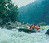
Yough River Water Trail Map And Guide Published
|
|
The Pennsylvania Environmental Council has published a two-part map and guide to promote boating on the newly designated Youghiogheny River Water Trail.
The water trail was developed in cooperation with the state Department of Conservation and Natural Resources and the Fish and Boat Commission as part of the Laurel Highlands Conservation Landscape Initiative. Water Trails identify natural features, historic sites and other points of interest; hazards; boat rentals, liveries and outfitters; and directions to public access areas. "Many people are aware of the Lower Yough, known nationally for its whitewater, but other sections of the river are very different," said Don Welsh, President and CEO of PEC. "The Southern Yough carves through Pennsylvania's deepest river gorge before rushing over scenic Ohiopyle Falls and into the whitewater portion of the river. The Northern Yough offers flatwater boating through a scenic corridor that's incredibly rich in history - the surrounding coal fields produced more wealth than the California Gold Rush and Comstock Silver Load combined." "The goal of our Conservation Landscape Initiative is to create a model for how Pennsylvania can sustain its most special landscapes, and certainly the Yough River as it follows the Great Allegheny Passage land trail is one of those landscapes," said John Quigley, Acting Secretary of DCNR. "This water trail will help to create a sustainable and vibrant region. Plus, it offers people the chance to connect with the outdoors. If they make that connection, they will understand the importance of taking care of our natural resources." The Yough is unusual in that it flows north, starting in West Virginia and Maryland. The water trail begins below Youghiogheny River Lake, an Army Corps of Engineers flood-control dam, and continues 74 miles to McKeesport, where it enters the Monongahela River. The Southern Section of the map and guide covers Confluence to South Connellsville and describes the Middle Yough, which is Pennsylvania's deepest river gorge as it flows through Laurel Ridge, and the Lower Yough, noted for its whitewater. The Northern Section of the map and guide covers Connellsville to McKeesport and describes numerous historic sites, communities and other points of interest along the flatwater river. A copy of the Youghiogheny River Water Trail Guide is available online. For a list of all water trail guides available, visit the Fish and Boat Commission website. |
|
|
7/6/2009 |
|
| Go To Preceding Article Go To Next Article |