 09/02/24 - 146 New Stories - REAL Environmental & Conservation Leadership In PA: http://tinyurl.com/yck6vkb4
| Share this: | ||||

|

|

|

|

|
|
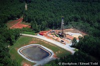
DCNR Releases GIS Maps On Impacts Of Leasing Additional State Forest Land For Drilling
|
|
The Department of Conservation and Natural Resources this week released a new series of GIS maps showing the potential impacts of leasing additional State Forest land for Marcellus Shale natural gas drilling. DCNR said gas drilling on State Forest land has impacts on plants and animals, on the integrity of the forest, and on recreational users of our public lands. DCNR manages State Forest lands with an eye toward balancing the various values and uses, to protect the health of our forests now, and 100 years from now.
Currently, 700,000 acres of our 2.2 million acre State Forest are available for natural gas extraction.
To demonstrate whether a moratorium is needed, DCNR released a series of GIS maps showing how additional natural gas leasing on state forest land will impact water quality, ecological integrity, backcountry recreation, scenic beauty and other social and environmental values.
Visit the DCNR Moratorium webpage and download the GIS maps for more information.
|
|
|
7/26/2010 |
|
| Go To Preceding Article Go To Next Article |