 04/15/24 - 66 New Stories - REAL Environmental & Conservation Leadership In PA: http://tinyurl.com/msuwtctm
| Share this: | ||||

|

|

|

|

|
|
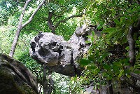
Visitors Explore Geology At Ohiopyle State Park
|
|
Ohiopyle State Park visitors recently were invited to take a step back in time—way back in time—to trace the evolution of the landscape and other geologic history of the Fayette County park with the many rock formations. Participants in the September 29 Geology Day were able to learn about the geologic characteristics of park outcroppings, ranging in age from Middle Pennsylvanian (310 MY) to Late Devonian (370 MY), and observe how they have undergone faulting, folding, and differential weathering over the last 200 million years. The day featured challenging climbs up the side of the Youghiogheny River gorge to see evidence of how large car-sized boulders had moved down slope more than a quarter of a mile during the Pleistocene Epoch (1.8 MY–12,000 Y) due to solifluction. Also, while high up on the side of the gorge, participants were taken to see a rock layer with distinct characteristics they later would encounter again two miles downstream near the top of Ferncliff Peninsula. The same rock, however, would not be in the form of massive ledges cropping out along the steep sides of a gorge, but would be in the form of large rounded boulders lying on the surface about 100 feet above the river. A discussion then followed on how the river had eroded the landscape and transported materials. At Ferncliff, the group also examined joint patterns in the sandstone cliff faces to see how those patterns were related to the alignment of the river channel. While at a stop at Ohiopyle Falls they were able to see close up the erosive forces of the river and estimate the movement of some of the larger sized boulders by examining historical photographs. To appreciate how the geologic structure and lithologic character of the rock helped to determine the profile of Laurel Ridge Mountain, participants followed resistant sandstone layers of the Pottsville Formation as it climbed up the western flank of the Laurel Hill anticline from Ohiopyle Falls to Baughman Rock and up to Turtlehead Rock Bog located near the crest of the anticline at the top of Laurel Ridge. Recent carbon-14 dating of organics found near the deepest portion of the bog indicates that it is nearly 1,000 years old. The bog was formed between large sandstone boulders from the Pottsville Formation that probably separated during a periglacial period perhaps more than 20,000 years ago. The author and Rose Fuge and Jordan Duvall environmental education specialists with the from the Bureau of State Parks led the all-day trip. Participants included geology students from the University of Pittsburgh main campus and the general public. (Written by James Shaulis is a geologist with DCNR's Bureau of Topographic and Geologic Survey and reprinted from the DCNR Resource online newsletter.) |
|
|
11/12/2012 |
|
| Go To Preceding Article Go To Next Article |