| Share this: | ||||

|

|

|

|

|
|
SRBC, Silver Jackets Release New Flood Inundation Maps For Sunbury, Bloomsburg, Danville, Wilkes-Barre & Communities In Between
|
|
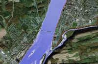
On April 12, the Susquehanna River Basin Commission, in partnership with the Pennsylvania Silver Jackets, has developed a tool that helps to show how far and deep the Susquehanna River extends at different flood levels. Referred to as an inundation map, it is available online through the National Oceanic and Atmospheric Administration’s NWS Advanced Hydrologic Prediction Service (NOAA AHPS). (Once at the website, use the interactive national map to select your particular point of interest in Pennsylvania, or select the specific location from the list below the map.) “It’s a valuable tool for community officials and emergency managers to plan and prepare for an impending flood, as well as provide the general public an understanding of the relative risk of flooding within their communities,” said Ben Pratt, Water Resources Engineer at SRBC. He noted that the tool covers river forecast points located at Sunbury, Bloomsburg, Danville, and Wilkes-Barre and shows the areas where minor and major flooding would occur in and around those places. These flood inundation maps are different that federal flood insurance maps which are used to set flood insurance rates. The NOAA AHPS flood inundation maps are meant to strictly convey flood risk associated with specific flood stages as measured at local flood gages. NOAA AHPS flood inundation maps are also available for Harrisburg and Jersey Shore. Click Here for a list of mapping available. The Pennsylvania Silver Jackets Team is an interagency team dedicated to working collaboratively with the commonwealth and appropriate stakeholders in developing and implementing solutions to flood hazards by combining available agency resources, which include funding, programs, and technical expertise. Team members responsible for completing this project include United States Army Corps of Engineers, National Weather Service, Luzerne County Flood Protection Authority, SRBC, Federal Emergency Management Agency, and the Pennsylvania Emergency Management Agency. Questions about the inundation map can be directed to Ben Pratt at 717-238-0425 ext. 1212 or send email to: bpratt@srbc.net. For more information on programs, training opportunities and upcoming events, visit the Susquehanna River Basin Commission website. Click Here to sign up for SRBC’s newsletter. Follow SRBC on Twitter, visit them on YouTube. NewsClips: No Federal Money For Last Year’s Floods In Lancaster County Work Held Up On Solomon Creek Flood Control Project In Wilkes-Barre Scranton Gets 2 Proposals On Stormwater Management Allen Twp Mulls Over Potential Stormwater Compliance Projects Plan To Remove Dams From Mahoning River Is Taking Off Still Reeling From 2018 Rainfall, PA Farmers Offered Emergency USDA Loans Midwest Flooding Behind Skyrocketing Gasoline Prices Senators Bartolotta, Stefano Would Open State Forests To Drilling To Fund Restore PA-Like Proposal Senators Offer Alternative To Gov. Wolf’s Restore PA Plan Related Stories: April PA Township News: Is Your Township Prepared For Flooding? Not Your Mama’s Playground Susquehanna River Basin Commission Highlights Partnership Efforts In 2018 Annual Report [Posted: April 12, 2019] |
|
|
4/15/2019 |
|
| Go To Preceding Article Go To Next Article |