| Share this: | ||||

|

|

|

|

|
|
Penn State, Carnegie Mellon Students, Staff Work With Pittsburgh Municipalities To Predict Geohazards
|
|
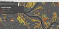
Penn State students, Carnegie Mellon students, Penn State faculty and staff from the Franco Harris Pittsburgh Center at Penn State, are collaborating to use existing fiber optic cables to predict dangerous geohazards like flooding, landslides and sinkholes, in Pittsburgh. Within the core team of this project is David Himes, registered landscape architect and sustainable communities manager for the Franco Harris Pittsburgh Center — a service of Penn State Outreach. Himes works with Penn State researchers and local community leaders and residents in the Pittsburgh area to better understand their needs, identify areas of impact and work on solutions. “From living and working in Pittsburgh for decades, we have developed personal relationships with community members and municipalities,” Himes said. “We can get them to the table, so their issues are identified. We can expand their data collection and problem-solving abilities.” One of the community partners Himes works with is Beth Dutton, senior project manager specializing in stormwater for the Pittsburgh Water and Sewer Authority. Himes facilitates conversations between Dutton and researchers in the effort to reduce risks of geohazards to both rural and urban communities in the Pittsburgh area. “PWSA’s infrastructure presents unique challenges in identifying, prioritizing, and funding the most important areas for system rehabilitation and upgrades to help address capacity issues related to stormwater that cause sewer overflows and basement sewer backups,” Dutton said. “This project is exciting because of the prospect of leveraging existing infrastructure in easy-to-implement and economic ways, to gain valuable new information on the environmental challenges that we’re trying to manage.” Tieyuan Zhu, associate professor in the Department of Geosciences in the College of Earth and Mineral Sciences (EMS) at Penn State, said he and his team first experimented with using telecommunication fiber optic cables to detect geohazards at the Penn State University Park campus. After more than two years of success, the National Science Foundation Civic Innovation Challenge (CIVIC) funded the use of this technology in a large-scale city. “Pittsburgh is a typical east coast city, with its diverse geological landscape and history of geohazard occurrences. It served as a valuable testing ground,” Zhu said. “We expect to assess the effectiveness of our technology in real-world scenarios and refine its capabilities.” Himes said he provided geospatial analysis to overlay fiber optic networks, existing and potential sites for geohazards, resident 311 complaints and environmental justice communities to assess candidate research corridors that could have the highest impact to Pittsburgh neighborhoods. His understanding of local social geographies has helped Zhu to frame the research in terms of Pittsburgh issues and desired outcomes. Zhinong Wang, postdoctoral researcher in the Department of Geosciences, and Junzhu Shen, Ph.D. candidate specializing in seismology in the Department of Geosciences, are also working with Zhu to use fiber optic cables known as Distributed Acoustic Sensing (DAS) to collect detailed information about what is happening underground that can significantly reduce the cost of exploring and monitoring geological hazards. Also on Zhu’s team is Jackson Saftner, Ph.D. candidate in EMS. He said the process they used to find where to collect data is called tap testing. “We had a map of where the fiber optic cables should be in the city, so we would go to street corners just above where we thought it was and smack the ground a couple times to confirm it was there and working,” Saftner said. “We would then record the channel number that the energy was observed on, and the street name where the tap-test was conducted. Tying these two bits of information together helps put the seismic data we record in good spatial context and then we wait for the data to accumulate.” Collaborators on this project created a call to action for communities by encouraging residents to share their observations and experiences related to geohazards on the Engage Pittsburgh website. Researchers said they plan to develop and implement a joint action plan to address identified geohazards, prioritizing areas with the highest risk and share the collected data and community feedback with relevant municipal authorities. Click Here to watch a video presentation about Pittsburgh geohazards and the project. Questions should be directed to Christie Black, Assistant Director of News and Communications, Penn State Outreach and Online Education, by sending email to: cxb81@psu.edu. (Courtesy of Franco Harris Pittsburgh Center at Penn State, Pittsburgh.) Related Article: -- State Museum Of PA Hosts Aug. 16 Virtual Program On How The PA Geological Survey Uses Satellite Data And You Can Too [PaEN] [Posted: August 8, 2024] |
|
|
8/12/2024 |
|
| Go To Preceding Article Go To Next Article |