| Share this: | ||||

|

|

|

|

|
|
Report Recommends Improvements to Susquehanna Flood Warning System
|
|
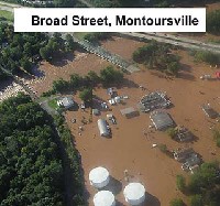
The Susquehanna River Basin Commission this week released a report making recommendations on how to improve the Commission’s Flood Forecast and Warning System. The report evaluates the System’s response to the June 25-26, 2006 flood that devastated much of southern tier The report evaluates the performance of the Susquehanna Flood Forecast and Warning System leading up to and during the flood, and makes recommendations for system improvements, including enhancing select stream gages, installing new rain and stream gages and improving the way weather data is collected, monitored, interpreted and disseminated to the public. "The Susquehanna system utilizes radar and a network of stream and rain gages to provide data used by the National Weather Service to forecast river levels and issue more timely and accurate early flood warnings," said Paul Swartz, SRBC Executive Director. "These early warnings help reduce flood damages by an average of $32 million annually throughout the Susquehanna basin, as businesses and residents have time to secure their property and get themselves to safer locations before flood waters strike." The SFFWS is maintained and operated by an interagency committee coordinated by SRBC since 1986 and comprised of representatives from the federal government and the states of The goal of the SFFWS is to provide at least 6 hours of advance warnings. While the National Weather Service forecasters achieved the 6-hour goal during the June 2006 flood, the storm proved difficult to track and certain gaps in the SFFWS became apparent. Following are 10 of the more than 35 recommended improvements listed in the June 2006 flood report (based on the interagency committee's own assessment and feedback received during several post-flood community dialogue and technical sessions convened by SRBC): · Flood-proof stream gage structures at Rockdale, Unadilla, Vestal and Conklin, N.Y; · Install and maintain real-time stream gages at · Expand precipitation monitoring network to fill gaps in coverage at or near Vestal, Waverly, Oneonta, Cuyler/Homer area and Haskinville/Cohocton area in · Extend the rating curves (that show the relationship between depth and river flow) at all river forecast points to 125 percent above the record flow, with priorities at Rockdale, Unadilla, Bainbridge, Conklin, Cortland, Sherburne, Green, Chenango Forks, Vestal, Owego, Waverly and Chemung in New York, and Tunkhannock, Old Forge and Bloomsburg in Pennsylvania; · Develop modeled forecast points for the Susquehanna River at Oneonta, · Develop crest-crest relationships for forecasts in · Provide more forecast information on the · Provide forecast information on the Codorus Creek in the · Increase and enhance web server capacity of the NWS' Advanced Hydrologic Prediction Services. (Users had difficulty obtaining current flood information during the June 2006 event due to web server exceeding capacity.); and · Develop flood inundation maps to provide emergency managers a functional tool to facilitate emergency response. The SFFWS interagency committee has already implemented some of the recommended improvements and has others under consideration. The implemented improvements to date include: U.S. Geological Survey is currently installing the new stream gage on the Swatara Creek at Middletown, Pa.; the NWS increased web server capacity to improve reliability; and SRBC is working with USGS and NWS to develop flood inundation map layers - currently for Binghamton, N.Y., and surrounding communities - and finalize logistics for installing rain and stream gages at several locations in New York Swartz said, "Given the tremendous damages suffered as a result of the June flood, many residents and businesses still are grappling with recovery efforts. The final damage estimates throughout the Susquehanna basin also are not yet fully known." Forty-eight of the 67 counties in the Susquehanna basin were impacted during the June 2006 flood, with the most severe flooding occurring in "As bad as this flood was, the Susquehanna basin is fortunate to have one of the best flood warning systems in place, and an extensive network of structural flood damage reduction projects," said Brig. General Todd Semonite, SRBC Federal Commissioner and North Atlantic Division Commander, U.S. Army Corps of Engineers. "The structural projects maintained by the Corps' Baltimore District averted nearly $1 billion in damages during the flood." The June 2006 Flood Report and information about the Susquehanna Flood Forecast and Warning System are available on the SRBC’s website. Hard copy reports are also available from SRBC by calling 717-238-0423 ext. 302 or by sending e-mail to: srbc@srbc.net. |
|
|
2/9/2007 |
|
| Go To Preceding Article Go To Next Article |